Bloomington
System Information
System Description
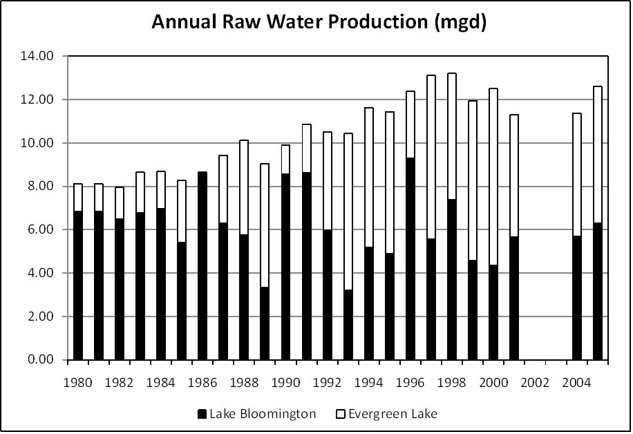
Water is pumped directly to the treatment plant from two impounding reservoirs, Lake Bloomington and Evergreen Lake. An intake on the Mackinaw River can pump up to 14,000 gpm into Evergreen Lake during droughts if required instream flows in the river are maintained.
Satellite Communities and Water Districts
Bloomington Township - West Phase, Crestwicke, Hudson, and Towanda
Population Served: |
72330 |
County: |
McLean |
Watersheds: |
Mackinaw |
Water Source
| Name |
Type |
Stream |
DA (sq mi) |
SA (ac) |
Capacity |
Year Est. |
Est. 2010 Cap. (ac-ft) |
| Lake Bloomington |
IR |
Money Cr |
69 |
540 |
6800 |
1999 |
6482 |
| Evergreen Lake |
IR |
Six Mile Cr |
|
900 |
15610 |
1999 |
15369 |
| Mackinaw River |
RW |
Mackinaw R |
400 |
|
|
|
|
1989 Study: |
20-year drought yield insufficient at 2000 level of water use. |
USGS Gages: |
Money Cr - Towanda (05564400), Hudson (05564500), Mackinaw R near Congerville (05567500) |
Developments since 1989:
The Evergreen Lake spillway was raised 5 feet in 1995. The Mackinaw River was used in 2000 and 2006. New groundwater sources are being evaluated, including a ~20 mgd regional supply in western McLean County and another in the Danvers bedrock valley of the Mahomet aquifer that could provide 2-3 mgd for blending when nitrate levels in Lake Bloomington are high.
Notes and Terminology
Vulnerability Report
Choose another Community

