Forecasting thunderstorm interactions with the Great Lakes

Schematic of storm structure changes as a squall line crossed over
upwind shoreline of Lake Erie. Modified from Workoff (2009, MS Thesis,
Dept. Atmospheric Sciences, University of Illinois).
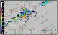
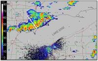
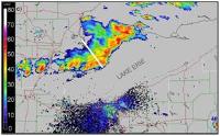
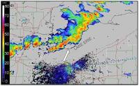
It is well-known that thunderstorms crossing the Great Lakes during the warm season usually weaken and produce less rain. However, how storm structures change across a lake and their impact on communities on the downwind shores are difficult to predict. One of our recent studies showed considerable changes in the structure of a squall line as it moved over Lake Erie. Workoff (2009, MS Thesis, Dept. Atmospheric Sciences, University of Illinois) found that as the squall line approached and moved over the shoreline, its intensity and forward motion changed considerably, the storm tilted backward and small bow echoes developed indicating strong winds reaching the surface. Severe, damaging winds were reported both upwind and downwind of the lake.
To develop an idea of the "usual" reactions to Lake Erie, Workoff et al. (2011) identified dozens of cases of convective storms moving over the lake during 2001-2009 and tracked their changes using WSR-88D radar observations. Among the findings are that isolated and clusters of storms tend to weaken much more rapidly than organized lines and mesoscale convective complexes of storms. Collaborative efforts at Hobart and William Smith Colleges, in Geneva, NY, are focusing of storm changes over Lake Michigan. This work is also being conducted in collaboration with the NOAA National Weather Forecast Office in Cleveland, OH.


Time series of WSR-88D radar observations of a squall line crossing over upwind shoreline of Lake Erie. Modified from Workoff (2009, MS Thesis, Dept. Atmospheric Sciences, University of Illinois).